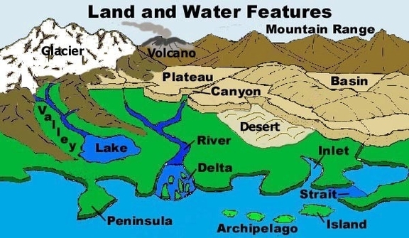
Geography Terms

Geography Terms: this diagram is one of our most searched charts and infographics by people seeking to learn about new things and improve their general knowledge of how the world works.

Geography Terms

Here is a list of some important geography terms:

1. Absolute location: The particular location of a point on Earth’s surface that can be expressed by a grid reference such as latitude and longitude .
2. Accessibility: A locational characteristic that permits a place to be reached by the efforts of those at other places .
3. Active volcano: A volcano that is currently erupting, or one that has erupted within the last 10,000 years (the Holocene) or during recorded history .
4. Alluvial fan: A distinctly triangular or fan-shaped deposit of sediment transported by water, often referred to as alluvium. Alluvial fans usually form at the base of mountains, where high-velocity rivers or streams meet a relatively flat area and lose the energy needed to carry large quantities of sediment, which ultimately spreads out in all available directions. They tend to be larger and more obvious in arid regions .
5. Alluvial plain: A wide, flat, gently sloping plain created by the long-term deposition of alluvium from one or more rivers flowing from highland regions, and typically characterized by various fluvial landforms such as braided streams, terraces, and meanders. Alluvial plains encompass the larger area over which a river’s floodplain has shifted through geological time .
6. Antipodes: Either or both of two points, places, or regions that are situated diametrically opposite to one another on the earth’s surface, especially the country or region opposite one’s own .
7. ArĂȘte: A sharp ridge separating two cirques or glacial valleys in mountainous regions .
8. Atlas: A collection of maps, usually in book form .
9. Atmosphere: The gaseous envelope surrounding the earth or any other celestial body .
10. Atoll: A circular coral reef or string of coral islands surrounding a lagoon .
11. Bay: A wide semicircular indentation of a shoreline, especially between two headlands or peninsulas .
12. Beach: An extensive area of sand or shingle sloping down to a sea or lake, especially the area between the high- and low-water marks on a seacoast .
13. Canyon: A gorge or ravine, especially in North America, usually formed by the down-cutting of a river in a dry area where there is insufficient rainfall to erode the sides of the valley .
14. Climate: The long-term prevalent weather conditions of an area, determined by latitude, position relative to oceans or continents, altitude, etc. .
15. Continent: That part of the earth’s crust that rises above the oceans and is composed of sialic rocks .